
Hurricane Juliette (2001)
 Juliette at peak intensity off the Mexican coast on September 25 | |
| Meteorological history | |
|---|---|
| Formed | September 21, 2001 |
| Dissipated | October 3, 2001 |
| Category 4 major hurricane | |
| 1-minute sustained (SSHWS/NWS) | |
| Highest winds | 145 mph (230 km/h) |
| Lowest pressure | 923 mbar (hPa); 27.26 inHg |
| Overall effects | |
| Fatalities | 12 total |
| Damage | $400 million (2001 USD) |
| Areas affected | Baja California Peninsula, Western Mexico, Southern California, Arizona |
| IBTrACS | |
Part of the 2001 Pacific hurricane season | |
Hurricane Juliette was a powerful Pacific hurricane that struck Mexico in September 2001. A long-lived tropical cyclone, Juliette originated from a tropical wave that exited western Africa, the same wave that earlier spawned Atlantic Tropical Depression Nine near Nicaragua on September 19. Two days later, a new tropical depression developed offshore Guatemala, which became Hurricane Juliette by September 22 as it rapidly intensified off western Mexico. On September 24 it strengthened into a Category 4 hurricane on the Saffir-Simpson scale, only to weaken due to an eyewall replacement cycle, then re-intensified a day later to attain maximum sustained winds of 230 km/h (145 mph), with a minimum barometric pressure of 923 mbar (27.3 inHg). Juliette weakened as it moved toward the Baja California peninsula, producing hurricane-force winds and torrential rainfall across Baja California Sur. On September 30 after the hurricane had weakened, Juliette made landfall near San Carlos as a minimal tropical storm. After drifting across the Gulf of California, Juliette dissipated on October 3.
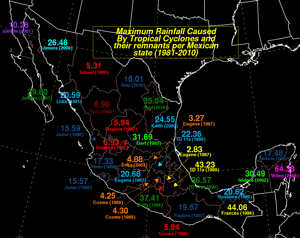
During its path across the Pacific, Juliette affected much of southwestern Mexico. The strongest winds and heaviest rainfall occurred in Baja California Sur, with a precipitation total of 1,011 mm (39.80 in) recorded at Santiago. Damage in the country reached over Mex$1.755 billion (US$188 million, of which the worst effects were in the state of Sonora. There, the rains over three days equaled the average annual precipitation, which resulted in significant flooding.
Meteorological history[edit]

Tropical storm (39–73 mph, 63–118 km/h)
Category 1 (74–95 mph, 119–153 km/h)
Category 2 (96–110 mph, 154–177 km/h)
Category 3 (111–129 mph, 178–208 km/h)
Category 4 (130–156 mph, 209–251 km/h)
Category 5 (≥157 mph, ≥252 km/h)
Unknown
A tropical wave exited the west coast of Africa on September 11. The wave moved westward across the Atlantic Ocean without development, reaching the Caribbean Sea on September 16. Three days later, the convection expanded and became increasingly organized. At 18:00 UTC on September 19, Tropical Depression Nine developed in the southwestern Caribbean Sea, located about 60 mi (95 km) north-northwest of San Andrés.[1] Upon its formation, the depression already had a circular upper-level outflow, which National Hurricane Center (NHC) forecaster Stacy Stewart described as "impressive... more indicative of a mature tropical cyclone." The NHC anticipated that the westward track would continue, ultimately resulting in a significant tropical cyclone in the eastern Pacific Ocean.[2] The depression moved ashore northeastern Nicaragua early on September 20 near Puerto Cabezas, and soon after, the surface circulation dissipated over the mountains of Central America.[1]
The remnants of the depression continued westward into the eastern Pacific Ocean, which quickly reorganized. At 06:00 UTC on September 21, a small tropical depression developed about 165 km (105 mi) south of Guatemala. A ridge steered the system west-northwestward, parallel to the coast about 185 to 370 km (115 to 230 mi) offshore. Despite the proximity to land, the small system quickly intensified due to warm water temperatures and light wind shear. At 18:00 UTC on September 21, the NHC initiated advisories on the system, naming it Tropical Storm Juliette, based on observations from the Hurricane Hunters.[3][4] With the favorable environmental conditions, tropical cyclone forecast models anticipated that the storm would intensify within the next two days.[5] Although the thunderstorms temporarily decreased near its center, Juliette developed good outflow by September 22, a sign of a maturing tropical cyclone.[6] Early the next day, a central dense overcast developed over the circulation as the structure became more symmetrical.[7] Later that day, an eye developed in the center of the convection, and by 12:00 UTC, Juliette attained hurricane status, with maximum sustained winds reaching 120 km/h (75 mph).[8][3]
Upon becoming a hurricane, Juliette was undergoing rapid intensification. Late on September 23, the hurricane developed a pinhole eye, which was embedded within the central dense overcast, and surrounded by rainbands.[3][9] Early on September 24, Juliette executed several small cyclonic loops. NHC forecaster Stacy Stewart noted that "this type of erratic motion is not unusual for tropical cyclones that undergo rapid deepening." At 06:00 UTC on September 24, the hurricane attained an initial peak intensity of 215 km/h (130 mph), making Juliette a Category 4 on the Saffir-Simpson scale. It had strengthened by 110 km/h (70 mph) over 24 hours. The tropical cyclone forecast models anticipated further strengthening, possibly to Category 5 intensity.[10][3] However, the hurricane underwent an eyewall replacement cycle, in which the small inner eye dissipated, causing the winds to drop to 175 km/h (110 mph) by late on September 24.[3] By early the next day, a well-defined 19 km (11 mi) eye had redeveloped in the center of the convection, signaling that Juliette was restrengthening.[11] The Hurricane Hunters observed a minimum pressure of 923 mbar (27.3 inHg) on September 25, which at the time was the second-lowest pressure ever recorded in the eastern Pacific Ocean, after Hurricane Ava in 1973. Observations also indicated sustained winds of at least 218 km/h (136 mph), although satellite-estimated winds were as high as 260 km/h (160 mph). The NHC assessed that Juliette attained peak winds of 230 km/h (145 mph).[3][12]

Shortly after its peak, Juliette's path turned more to the northwest toward the Baja California peninsula, drawn northward by an eastward-moving trough off the west coast of the United States. Also around that time, the hurricane underwent another eyewall replacement cycle.[3][13] Early on September 27, the Hurricane Hunters observed three concentric eyewalls, which forecaster Jack Beven described as "a rather uncommon occurrence." By that time, Juliette was weakening as its convective organization deteriorated.[14][3] Early on September 28, the hurricane passed about 110 km (70 mi) west of Cabo San Lucas along the southern tip of the Baja California peninsula. Around that time, Juliette had sustained winds of 130 km/h (80 mph), with diminished thunderstorms near the center.[15][3][16] The combination of land interaction and cooler temperatures caused the hurricane to weaken further, and Juliette briefly dropped to tropical storm status late on September 28. Its motion also slowed, as the trough to the north had weakened.[3][17] The thunderstorms redeveloped over the center early on September 29, and Juliette re-intensified to hurricane status for about 12 hours, only to weaken again due to land interaction.[18][19] By late on September 29, the circulation was exposed from the convection, although rainbands extended far from the center into the southwestern United States.[20] At around 00:00 UTC on September 30, Juliette made landfall near San Carlos, Baja California Sur, with winds of about 65 km/h (40 mph).[3]
Soon after moving over land, Juliette weakened into a tropical depression and became disorganized, as stronger wind shear stripped the thunderstorms from the circulation. It quickly crossed the Baja California peninsula and emerged into the Gulf of California. A building ridge turned the circulation northwestward as thunderstorms redeveloped.[3][21][22] The NHC discontinued advisories on October 1 while Juliette was near Tiburón Island, assessing that the depression moved inland. Instead, the circulation continued to the northwest over water, and the NHC resumed advisories on October 2, after Juliette generated enough thunderstorms to be designated a tropical depression. Moving westward, the circulation dissipated on October 3 in the northern Gulf of California, just offshore Puertecitos.[3][23][24]
Preparations[edit]
Upon Juliette's designation as a tropical cyclone on September 21, the Government of Mexico began issuing various tropical cyclone warnings and watches for southern portions of the country, as far as east as Salina Cruz, Oaxaca. Although the warnings were dropped on September 22, additional tropical storm warnings were issued a day later for southwestern Mexico. The government of Mexico issued tropical storm warnings for the southern Baja California peninsula on September 26, two days before Juliette's closest approach to the region. A day later, the government of Mexico issued hurricane warnings between Cabo San Lázaro along the west coast of the peninsula to El Burro along the east coast. In addition, tropical storm warnings were posted for the eastern coastline of the Gulf of California from Mazatlán to Yavaros. The watches and warnings were canceled as Juliette weakened.[3]
Impact[edit]

When the depression struck Nicaragua, Puerto Cabezas recorded sustained winds of 48 km/h (30 mph).[1]
Mexico[edit]
A large cyclone, Juliette affected much of the Pacific coast of Mexico with clouds, rainfall, and high waves, particularly Baja California Sur.[25] A weather station in Cabo San Lucas recorded sustained winds of 141 km/h (87 mph), with gusts to 174 km/h (108 mph).[3] Earlier while Juliette was near its peak intensity, it produced gusts of 74 km/h (46 mph) in Manzanillo.[13] The heaviest rainfall occurred along the southern tip of the Baja California peninsula, with a maximum precipitation total of 1,011 mm (39.80 in) recorded at Santiago. This was among the wettest known tropical cyclones in northwestern Mexico. In neighboring Baja California, Juliette produced a rainfall total of 261 mm (10.28 in). Also in the state, the highest 24 hour rainfall total in the country was 207.2 mm (8.16 in) in San Felipe. Across the Gulf of California, parts of Sonora experienced significant rainfall, the equivalent of a year's worth of precipitation over three days. A station along the Mayo River recorded 380 mm (15 in).[3][25][26][27][28]
Damage from Hurricane Juliette was estimated at $400 million (2001 USD).[29] The heaviest damage was in Baja California Sur and Sonora, with 18,873 houses and 273 schools damaged between the two states. The combined damage total between the two states was Mex$1.755 billion (US$188 million). The heaviest damage was in Sonora, where the rains led to flash flooding along several river valleys, including the Mayo, Yaqui, San Marcial, and Sonora. Floodwaters temporarily isolated the city of Empalme. The floods also damaged agriculture and fishing industries, impacting the shrimp output of the region.[28]
Along coastal areas around Acapulco, the storm brought heavy rainfall and strong winds.[30] Offshore, one fisherman was killed by the storm after he set sail directly into it. In Guerrero, heavy rains triggered flash floods that washed out two bridges and destroyed 20 homes.[31] As rains continued to fall over the following days, mountainsides gave way, producing landslides which killed seven people. Strong winds also uprooted trees and downed power lines in several states. Additionally, two fishermen were listed as missing after venturing out into 5 metres (16 ft) swells produced by Juliette.[32] Throughout Michoacán, an estimated 1,000 people were left homeless by the hurricane.[33]
The extreme rainfall led to widespread flooding and mudslides across Baja California. Along the southern tip of the peninsula, roughly 3,000 people were stranded after their town was isolated by flood waters. About 800 more people had to be evacuated due to the state of their homes.[34] Damage from the floods were widespread in the area, with more than 9,000 people reported damage to their property from the storm. At least two people were killed across the peninsula in storm-related incidents.[35]
Southwestern United States[edit]
As Juliette moved into northwestern Mexico, its produced clouds thunderstorms across the southwestern United States. In the California, the thunderstorms produced a dust storm and a wind gust of 39 mph (63 km/h), recorded at Palm Springs International Airport. The winds knocked down trees and power lines. Rainfall in the United States peaked at 23 millimetres (.9 in) in Patagonia, Arizona.[36][3][37]
Aftermath[edit]
Following the significant damage across southern states, Mexican authorities and the army deployed transport and rescue aircraft along with medical teams and emergency supplies.[33] As reports of damage began to come out of Baja California Sur, the state governor declared the entire area a disaster zone.[34]
See also[edit]
- Other storms named Juliette
- List of Category 4 Pacific hurricanes
- List of Baja California Peninsula hurricanes
References[edit]
- ^ a b c Jack Beven (October 24, 2001). Tropical Depression Nine Tropical Cyclone Abbreviated Report (PDF) (Report). National Hurricane Center. Retrieved June 13, 2024.
- ^ Stacy Stewart (September 19, 2001). "Tropical Depression Nine Discussion 1". National Hurricane Center. Retrieved June 13, 2024.
- ^ a b c d e f g h i j k l m n o p q Lawrence, Miles B.; Mainelli, Michelle M. (November 30, 2001). Tropical Cyclone Report: Hurricane Juliette (PDF) (Report). National Hurricane Center. Retrieved August 25, 2020.
- ^ Franklin, James (September 21, 2001). "Tropical Storm Juliette Discussion 1". National Hurricane Center. Retrieved June 22, 2024.
- ^ Lixion Avila (September 22, 2001). "Tropical Storm Juliette Discussion 3". National Hurricane Center. Retrieved June 22, 2024.
- ^ Stacy Stewart (September 22, 2001). "Tropical Storm Juliette Discussion 4". National Hurricane Center. Retrieved June 22, 2024.
- ^ Stacy Stewart (September 23, 2001). "Tropical Storm Juliette Discussion 7". National Hurricane Center. Retrieved June 22, 2024.
- ^ Stacy Stewart (September 23, 2001). "Tropical Storm Juliette Discussion 8". National Hurricane Center. Retrieved June 22, 2024.
- ^ Lixion Avila (September 23, 2001). "Hurricane Juliette Discussion 10". National Hurricane Center. Retrieved June 22, 2024.
- ^ Stacy Stewart (September 24, 2001). "Hurricane Juliette Discussion 11". National Hurricane Center. Retrieved June 22, 2024.
- ^ Stacy Stewart (September 25, 2001). "Hurricane Juliette Discussion 16". National Hurricane Center. Retrieved June 22, 2024.
- ^ Richard Pasch (September 25, 2001). "Hurricane Juliette Discussion 19". National Hurricane Center. Retrieved June 22, 2024.
- ^ a b Jack Beven (September 26, 2001). "Hurricane Juliette Discussion 20". National Hurricane Center. Retrieved June 22, 2024.
- ^ Jack Beven (September 27, 2001). "Hurricane Juliette Discussion 24". National Hurricane Center. Retrieved June 22, 2024.
- ^ James Franklin (September 28, 2001). "Hurricane Juliette Intermediate Advisory Number 28A". National Hurricane Center. Retrieved June 22, 2024.
- ^ Jack Beven (September 28, 2001). "Hurricane Juliette Discussion 28". National Hurricane Center. Retrieved June 22, 2024.
- ^ Lixion Avila (September 28, 2001). "Hurricane Juliette Discussion 30". National Hurricane Center. Retrieved June 22, 2024.
- ^ Jack Beven (September 29, 2001). "Hurricane Juliette Discussion 32". National Hurricane Center. Retrieved June 22, 2024.
- ^ Lixion Avila (September 29, 2001). "Tropical Storm Juliette Discussion 34". National Hurricane Center. Retrieved June 22, 2024.
- ^ Lixion Avila (September 29, 2001). "Tropical Storm Juliette Discussion 35". National Hurricane Center. Retrieved June 22, 2024.
- ^ Jack Beven (September 30, 2001). "Tropical Depression Juliette Discussion 36". National Hurricane Center. Retrieved June 22, 2024.
- ^ Robert Pasch; Ed Rappaport (September 30, 2001). "Tropical Depression Juliette Discussion 39". National Hurricane Center. Retrieved June 22, 2024.
- ^ Stacy Stewart (October 1, 2001). "Tropical Depression Juliette Discussion 40". National Hurricane Center. Retrieved June 22, 2024.
- ^ Stacy Stewart (October 1, 2001). "Tropical Depression Juliette Advisory Number 40". National Hurricane Center. Retrieved June 22, 2024.
- ^ a b Huracán Juliette (PDF) (Report) (in Spanish). Servicio Meteorológico Nacional. Retrieved June 23, 2024.
- ^ David Roth (May 12, 2022). "Hurricane Juliette - September 25-October 3, 2001". Weather Prediction Center. Retrieved June 23, 2024.
- ^ "Maximum Rainfall Caused by Tropical Cyclones and their remnants per Mexican state (1981-2010)". Weather Prediction Center. May 12, 2022. Retrieved June 23, 2024.
- ^ a b Daniel Bitrán Bitrán; Lorena Acosta Colsa; Héctor Eslava Morales; Carlos Gutiérrez Martínez; Marco Antonio Salas Salinas; María Teresa Vázquez Conde (November 2002). Impacto Socioeconómico de los Principales Desastres Ocurridos en la Repúbkuca Mexicana en el Año 2001 (PDF) (Report). CENAPRED. ISBN 970-628-629-2. Retrieved June 24, 2024.
- ^ Centre for Research on the Epidemiology of Disasters. "EM-DAT: The Emergency Events Database". Université catholique de Louvain.
- ^ "Hurricane Juliette gathers strength, hits Mexican coast". ReliefWeb. Associated Press. September 23, 2001. Archived from the original on December 12, 2012. Retrieved July 7, 2010.
- ^ Agence France-Presse (September 24, 2001). "Hurricane Juliette leaves one dead, destruction in its wake". ReliefWeb. Retrieved July 7, 2010.
- ^ Deutsche Presse Agentur (September 26, 2001). "Hurricane Juliette leaves seven dead in Mexico". ReliefWeb. Retrieved July 7, 2010.
- ^ a b United Nations Office for the Coordination of Humanitarian Affairs (September 28, 2001). "OCHA Situation Report No. 4". ReliefWeb. Retrieved July 7, 2010.
- ^ a b United Nations Office for the Coordination of Humanitarian Affairs (September 29, 2001). "Mexico - Hurricane Juliette OCHA Situation Report No. 5". ReliefWeb. Retrieved July 7, 2010.
- ^ Deutsche Presse Agentur (September 29, 2001). "Hurricane "Juliette" leaves two dead in Mexico's Baja California". ReliefWeb. Retrieved July 7, 2010.
- ^ National Centers for Environmental Information. "Riverside County Event Report: Thunderstorm Wind". Storm Event Database. National Oceanic and Atmospheric Administration. Archived from the original on May 22, 2024. Retrieved May 22, 2024.
- ^ Roth, David M. (January 3, 2023). "Tropical Cyclone Point Maxima". Tropical Cyclone Rainfall Data. United States Weather Prediction Center. Retrieved January 6, 2023.
 This article incorporates text from this source, which is in the public domain.
External links[edit]
- Juliette effects in Cabo San Lucas
- HPC rainfall report for Juliette
- Boating Effects
- Early Effects
- Michoacán Effects
- After Effects
Tropical cyclones of the 2001 Pacific hurricane season | ||
|---|---|---|
 | ||
- 2001 Pacific hurricane season
- 2001 in Mexico
- Category 4 Pacific hurricanes
- Pacific hurricanes in Mexico
- Hurricanes in California
- Hurricanes in Arizona
- 2001 natural disasters in the United States
- Hurricanes and tropical depressions of the Gulf of California
- 2001 in California
- 2001 in Arizona
- September 2001 events in Oceania
- October 2001 events in Oceania
- Tropical cyclones in 2001