
Portal:Tropical cyclones
The Tropical Cyclones Portal

A tropical cyclone is a storm system characterized by a large low-pressure center, a closed low-level circulation and a spiral arrangement of numerous thunderstorms that produce strong winds and heavy rainfall. Tropical cyclones feed on the heat released when moist air rises, resulting in condensation of water vapor contained in the moist air. They are fueled by a different heat mechanism than other cyclonic windstorms such as Nor'easters, European windstorms and polar lows, leading to their classification as "warm core" storm systems. Most tropical cyclones originate in the doldrums, approximately ten degrees from the Equator.
The term "tropical" refers to both the geographic origin of these systems, which form almost exclusively in tropical regions of the globe, as well as to their formation in maritime tropical air masses. The term "cyclone" refers to such storms' cyclonic nature, with anticlockwise rotation in the Northern Hemisphere and clockwise rotation in the Southern Hemisphere. Depending on its location and intensity, a tropical cyclone may be referred to by names such as "hurricane", "typhoon", "tropical storm", "cyclonic storm", "tropical depression" or simply "cyclone".
Types of cyclone: 1. A "Typhoon" is a tropical cyclone located in the North-west Pacific Ocean which has the most cyclonic activity and storms occur year-round. 2. A "Hurricane" is also a tropical cyclone located at the North Atlantic Ocean or North-east Pacific Ocean which have an average storm activity and storms typically form between May 15 and November 30. 3. A "Cyclone" is a tropical cyclone that occurs in the South Pacific and Indian Oceans.
Selected named cyclone -

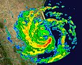
Extremely Severe Cyclonic Storm Fani (/ˈfɒniː/) was the worst tropical cyclone to strike the Indian state of Odisha since the 1999 Odisha cyclone. The second named storm and the first severe cyclonic storm of the 2019 North Indian Ocean cyclone season, Fani originated from a tropical depression that formed west of Sumatra in the Indian Ocean on 26 April. Vertical wind shear at first hindered the storm's development, but conditions became more favorable for Fani on 30 April. Fani rapidly strengthened, peaking at Category 5-equivalent intensity with winds of 280 km/h (175 mph), tying with Cyclone Mocha as the strongest storm on record in the north Indian Ocean, in terms of 1-minute sustained winds. Fani slightly weakened before making landfall, and its convective structure rapidly degraded thereafter, degenerating into a remnant low on 4 May, and dissipating on the next day. It was succeeded by Cyclone Amphan in 2020 which caused a greater overall damage.
Prior to Fani's landfall, authorities in India and Bangladesh moved at least a million people each from areas within Fani's projected path onto higher ground, and into cyclone shelters, which is thought to have reduced the resultant death toll and casualties. Fani killed at least 89 people in eastern India and Bangladesh and caused about US$8.1 billion in damages in both India and Bangladesh, mostly in Odisha, in India. (Full article...)Selected article -

The effects of Hurricane Charley in Jamaica included one fatality and at least $4.1 million in damages. Forming out of a tropical wave on August 9, 2004, Charley quickly tracked through the eastern Caribbean and attained tropical storm status on August 10. While passing south of Jamaica on August 11, the storm was upgraded to a Category 1 hurricane. During its passage of Jamaica, Charley had maximum winds of 75 mph (120 km/h), a low-end Category 1 hurricane. Turning north, the storm impacted western Cuba as a Category 3 storm before making landfall in Florida as a strong Category 4. The storm eventually dissipated on August 15. As Charley approached Jamaica, officials issued tropical storm watches and warnings before issuing a hurricane watch. Two cruise ships were diverted from docking in Jamaica, affecting 5,700 passengers. Numerous shelters were set up across the island; however, relatively few people sought refuge in them.
Although it was only a Category 1 hurricane, Charley caused significant damage in southern Jamaica. Saint Elizabeth Parish sustained the worst damage. About 750 farmers reported damage, and at one point, flooding isolated 30 families. The only fatality in Jamaica occurred after a man attempted to rescue a family but was swept away by flood waters. Following the storm, search and rescue teams were deployed to flooded regions. Days later, officials allocated roughly $7.6 million (JMD; US$86,000) to repair damaged roads. Residents in areas that sustained severe agricultural losses also requested assistance from the government. (Full article...)Selected image -
.jpg)
Selected season -

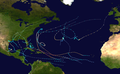
The 2017 Pacific hurricane season was an above average Pacific hurricane season in terms of named storms, though less active than the previous three, featuring eighteen named storms, nine hurricanes, and four major hurricanes. Despite the considerable amount of activity, most of the storms were weak and short-lived. The season officially started on May 15 in the eastern Pacific Ocean, and on June 1 in the central Pacific; they both ended on November 30. These dates conventionally delimit the period of each year when most tropical cyclones form in the respective regions. However, the formation of tropical cyclones is possible at any time of the year, as illustrated in 2017 by the formation of the season's first named storm, Tropical Storm Adrian, on May 9. At the time, this was the earliest formation of a tropical storm on record in the eastern Pacific basin proper (east of 140°W). The season saw near-average activity in terms of accumulated cyclone energy (ACE), in stark contrast to the extremely active seasons in 2014, 2015, and 2016; and for the first time since 2012, no tropical cyclones formed in the Central Pacific basin. However, for the third year in a row, the season featured above-average activity in July, with the ACE value being the fifth highest for the month. Damage across the basin reached $375.28 million (2017 USD), while 45 people were killed by the various storms.
Prior to the start of this season, the National Hurricane Center (NHC) changed its policy to permit issuance of advisories on disturbances that were not yet tropical cyclones but had a high chance to become one, and were expected to bring tropical storm or hurricane conditions to landmasses within 48 hours. As a result of this change, watches and warnings could be issued by local authorities. Such systems would be termed as "Potential Tropical Cyclones". The first system to receive this designation was Potential Tropical Cyclone Fourteen-E, which developed into Tropical Storm Lidia south-southeast of the Baja California Peninsula on August 30.
(Full article...)Related portals
Currently active tropical cyclones

Italicized basins are unofficial.
- North Atlantic (2024)
- No active systems
- East and Central Pacific (2024)
- No active systems
- West Pacific (2024)
- No active systems
- North Indian Ocean (2024)
- No active systems
- Mediterranean (2023–24)
- No active systems
- South-West Indian Ocean (2023–24)
- No active systems
- Australian region (2023–24)
- No active systems
- South Pacific (2023–24)
- No active systems
- South Atlantic (2023–24)
- No active systems
Last updated: 21:50, 2 June 2024 (UTC)
Tropical cyclone anniversaries

June 17,
- 1971 - Hurricane Bridget passed just to the south of Acapulco, Mexico bringing gusts of 100 mph (155 km/h) to the city. Many ships, including some naval ships, were sunk killing 40 people and causing $40 million of damage.
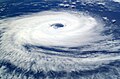
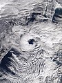
- 2012 - Typhoon Guchol (pictured) attains Category 4 super typhoon intensity with a minimum pressure of 930 hPa with 1-minute sustained winds of 240 km/h (150 mph).

June 18,
- 1965 - Typhoon Dinah made landfall in Taiwan with winds of 220 km/h (140 mph). Dinah killed a total of 45 people and destroyed 5,000 homes.
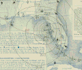
- 1982 - The 1982 Florida subtropical storm (track pictured) affects Florida. Damages were recorded at $10 million.
- 2003 - Tropical Storm Blanca reaches maximum intensity with winds of 95 km/h (60 mph) and a minimum pressure of 997 hPa.

June 19,
- 1959 - Hurricane Three, which caused the 1959 Escuminac disaster, looped in the Gulf of Saint Lawrence, sinking 22 of 54 fishing boats from Escuminac, New Brunswick. The storm killed a total of 35 people.
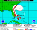
- 1993 - Tropical Storm Arlene (pictured) reaches tropical storm intensity prior to making landfall on Padre Island, Texas. Arlene killed a total of 29 people and caused about $55 million of damage, with most of the deaths occurring while it was a tropical wave.
Did you know…


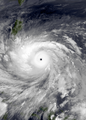
- …that the Joint Typhoon Warning Center considers that Typhoon Vera (pictured) of 1986 is actually two distinct systems, formed from two separated low-level circulations?
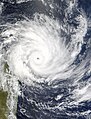
- …that Hurricane Agatha (pictured) was the strongest Pacific hurricane to make landfall in Mexico in May since records began in 1949?
- …that Cyclone Raquel (track pictured) travelled between the Australian and South Pacific basins between the 2014–15 and 2015–16 seasons, spanning both seasons in both basins?
- …that Cyclone Amphan (pictured) in 2020 was the first storm to be classified as a Super Cyclonic Storm in the Bay of Bengal since 1999?
General images -
-
 Broken concrete utility pole in Puerto Rico after Hurricane Maria in 2017, which ranks fourth in costliest US tropical cyclones. (from Effects of tropical cyclones)
 -
-
 Comparison between extratropical and tropical cyclones on surface analysis (from Cyclone)
 -
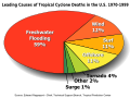 Percentages of hurricane deaths in the United States from 1970 to 1999. (from Effects of tropical cyclones)
 -
 The number of $1 billion Atlantic hurricanes almost doubled from the 1980s to the 2010s, and inflation-adjusted costs have increased more than elevenfold. The increases have been attributed to climate change and to greater numbers of people moving to coastal areas. (from Effects of tropical cyclones)
 -
 Tropical cyclones form when the energy released by the condensation of moisture in rising air causes a positive feedback loop over warm ocean waters. (from Cyclone)
 -
 Hurricane response involves working in hazardous conditions, including contamination and electrocution hazards from floodwater.
 -
 Surface weather map of the 1935 Labor Day hurricane moving up the west coast of Florida (from Tropical cyclone observation)
 -
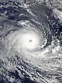
 Hurricane Catarina, a rare South Atlantic tropical cyclone viewed from the International Space Station on March 26, 2004 (from Cyclone)
 -
 Cyclone on Mars, imaged by the Hubble Space Telescope (from Cyclone)
 -
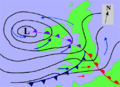
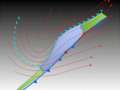 The initial extratropical low-pressure area forms at the location of the red dot on the image. It is usually perpendicular (at a right angle to) the leaf-like cloud formation seen on satellite during the early stage of cyclogenesis. The location of the axis of the upper level jet stream is in light blue. (from Cyclone)
 -
-
 A fictitious synoptic chart of an extratropical cyclone affecting the UK and Ireland. The blue arrows between isobars indicate the direction of the wind, while the "L" symbol denotes the centre of the "low". Note the occluded, cold and warm frontal boundaries. (from Cyclone)
 -
 All but the most expensive bottles of water were sold out at this Publix supermarket before Hurricane Irma; in the week preceding the storm, water sold out soon after shipments arrived (from Tropical cyclone preparedness)
 -
 (from Cyclone)
 -
 Chart with concurrent information for Hurricane Arlene and Tropical Storm Bret logged and plotted (from Tropical cyclone preparedness)
 -
 (from Cyclone)
 -
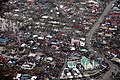 Aerial image of destroyed houses in Tacloban, following Typhoon Haiyan (from Effects of tropical cyclones)
 -
 An extratropical cyclone near Iceland (from Cyclone)
 -
 2017 Atlantic hurricane season summary map (from Cyclone)
 -
 Radar image of Hurricane Erika making landfall over Northeastern Mexico (from Tropical cyclone observation)
 -
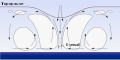
 The dangerous semicircle is the upper-right corner, with the arrow marking the direction of motion of a Northern Hemisphere storm. Note that typhoons, etc. are asymmetrical, and semicircle is a convenient misnomer. (from Effects of tropical cyclones)
 -
 Personnel and equipment from the National Guard of the United States en route to Hurricane Florence response efforts in 2018
 -
 Flooding in Port Arthur, Texas caused by Hurricane Harvey. Harvey was the wettest and second-costliest tropical cyclone in United States history. (from Effects of tropical cyclones)
 -
 (from Cyclone)
 -
 An example of a chart for Matthew showing its five-day forecast track (from Tropical cyclone preparedness)
 -

-
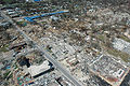
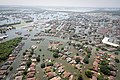
The aftermath of Hurricane Katrina in Gulfport, Mississippi. Katrina was the costliest tropical cyclone in United States history. (from Effects of tropical cyclones)
-
 A polar low over the Sea of Japan in December 2009 (from Cyclone)
 -
 (from Cyclone)
 -
 (from Cyclone)
 -
-
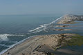 Hurricane Isabel (2003)'s effect on the North Carolina Outer Banks (from Effects of tropical cyclones)


.jpg)


.jpg)


.jpg)
_(50).jpg)


.png)


 Featured list -

The 2003–04 South Pacific cyclone season was a below-average season with only three tropical cyclones occurring within the South Pacific to the east of 160°E. The season officially ran from November 1, 2003 to April 30, 2004 with the first disturbance of the season forming on December 4 and the last disturbance dissipating on April 23. This is the period of the year when most tropical cyclones form within the South Pacific Ocean.
During the season at least 16 deaths resulted from tropical disturbances whilst overall damage was estimated at $218 million (2004 USD; $352 million 2024 USD). The most damaging tropical disturbance was Cyclone Heta which caused at least $211 million (2004 USD; $340 million 2024 USD) in damage to six different countries and left three dead. The deadliest tropical disturbance of the season was Tropical Depression 10F, which was responsible for eleven deaths and caused $2.74 million (2004 USD; $4.42 million 2024 USD) in damage. Cyclone Ivy also caused 2 deaths and caused $4.17 million (2004 USD; $6.73 million 2024 USD) worth of damage to Vanuatu. As a result of the impacts caused by Heta and Ivy, the names were retired from the tropical cyclone naming lists. (Full article...)Topics

Subcategories

Related WikiProjects
WikiProject Tropical cyclones is the central point of coordination for Wikipedia's coverage of tropical cyclones. Feel free to help!
WikiProject Weather is the main center point of coordination for Wikipedia's coverage of meteorology in general, and the parent project of WikiProject Tropical cyclones. Three other branches of WikiProject Weather in particular share significant overlaps with WikiProject Tropical cyclones:
- The Non-tropical storms task force coordinates most of Wikipedia's coverage on extratropical cyclones, which tropical cyclones often transition into near the end of their lifespan.
- The Floods task force takes on the scope of flooding events all over the world, with rainfall from tropical cyclones a significant factor in many of them.
- WikiProject Severe weather documents the effects of extreme weather such as tornadoes, which landfalling tropical cyclones can produce.
Things you can do
 |
Here are some tasks awaiting attention:
|
Wikimedia
The following Wikimedia Foundation sister projects provide more on this subject:
-
 Commons
Free media repository -
 Wikibooks
Free textbooks and manuals -
 Wikidata
Free knowledge base -
 Wikinews
Free-content news -
 Wikiquote
Collection of quotations -
 Wikisource
Free-content library -
 Wikiversity
Free learning tools -
 Wikivoyage
Free travel guide -
 Wiktionary
Dictionary and thesaurus


