
Portal:Myanmar
ကြိုဆိုပါတယ်။ / Welcome to the Myanmar Portal 

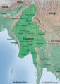
Myanmar, officially the Republic of the Union of Myanmar and also known as Burma (the official name until 1989), is a country in Southeast Asia. It is the largest country by area in Mainland Southeast Asia and has a population of about 55 million. It is bordered by Bangladesh and India to its northwest, China to its northeast, Laos and Thailand to its east and southeast, and the Andaman Sea and the Bay of Bengal to its south and southwest. The country's capital city is Naypyidaw, and its largest city is Yangon (formerly Rangoon).
Myanmar is a member of the East Asia Summit, Non-Aligned Movement, ASEAN, and BIMSTEC, but it is not a member of the Commonwealth of Nations despite once being part of the British Empire. Myanmar is a Dialogue Partner of the Shanghai Cooperation Organization. The country is very rich in natural resources, such as jade, gems, oil, natural gas, teak and other minerals, as well as also endowed with renewable energy, having the highest solar power potential compared to other countries of the Great Mekong Subregion. However, Myanmar has long suffered from instability, factional violence, corruption, poor infrastructure, as well as a long history of colonial exploitation with little regard to human development. In 2013, its GDP (nominal) stood at US$56.7 billion and its GDP (PPP) at US$221.5 billion. The income gap in Myanmar is among the widest in the world, as a large proportion of the economy is controlled by cronies of the military junta. Myanmar is one of the least developed countries; as of 2020, according to the Human Development Index, it ranks 147 out of 189 countries in terms of human development, the lowest in Southeast Asia. Since 2021, more than 600,000 people were displaced across Myanmar due to the surge in violence post-coup, with more than 3 million people in dire need of humanitarian assistance. (Full article...)
Selected articles -
-
![Image 1 Location of airport in Myanmar Yangon International Airport (Burmese: ရန်ကုန်အပြည်ပြည်ဆိုင်ရာလေဆိပ်; MLCTS: rankun apranyprany hcuingra lehcip [jàɴɡòʊɰ̃ əpjìpjì sʰàɪɴjà lèzeɪʔ]) (IATA: RGN, ICAO: VYYY) is the primary and busiest international airport of Myanmar. The airport is located in Mingaladon, 15 kilometres (9.3 mi) north of central Yangon. All ten Myanmar carriers and about 30 international airlines operate at Yangon International Airport. The airport is also colloquially known as Mingaladon Airport due to its location. Outside photo of the airport: (Full article...)](//upload.luquay.com/wikipedia/en/d/d2/Blank.png)
Yangon International Airport (Burmese: ရန်ကုန်အပြည်ပြည်ဆိုင်ရာလေဆိပ်; MLCTS: rankun apranyprany hcuingra lehcip [jàɴɡòʊɰ̃ əpjìpjì sʰàɪɴjà lèzeɪʔ]) (IATA: RGN, ICAO: VYYY) is the primary and busiest international airport of Myanmar. The airport is located in Mingaladon, 15 kilometres (9.3 mi) north of central Yangon. All ten Myanmar carriers and about 30 international airlines operate at Yangon International Airport. The airport is also colloquially known as Mingaladon Airport due to its location. Outside photo of the airport: (Full article...) -
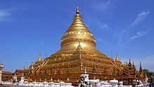
The Shwezigon Pagoda or Shwezigon Paya (ရွှေစည်းခုံဘုရား [ɕwèzíɡòʊɰ̃ pʰəjá]) is a Buddhist stupa located in Nyaung-U, Myanmar. A prototype of Burmese stupas, it consists of a circular gold leaf-gilded stupa surrounded by smaller temples and shrines. Construction of the Shwezigon Pagoda began during the reign of King Anawrahta (r. 1044–1077), the founder of the Pagan Empire, in 1059–1060 and was completed in 1102, during the reign of his son King Kyansittha. Over the centuries the pagoda had been damaged by many earthquakes and other natural calamities, and has been refurbished several times. In recent renovations it has been covered by more than 30,000 copper plates. However, the lowest level terraces have remained as they were.
This pagoda, a sacred Buddhist religious place, is believed to enshrine a bone and tooth of Gautama Buddha. The pagoda is in the form of a cone formed by five square terraces with a central solid core. There are footprints below the four standing Buddha statues here. Jataka legends are depicted on glazed terra-cotta tiles set into three rectangular terraces. At the entrance of the pagoda there are large statues of guardians of the temple. There are also four bronze standing statues of Buddha which are stated to be of the current age Buddha. At the outer limits of the pagoda there are 37 nats deified along with an intricately carved wooden sculpture of Thagyamin, the Burmese version of the Indian god Indra. Within the compound of the Shwezigon Pagoda there is a stone pillar containing Mon language inscriptions dedicated by Kyansittha. (Full article...) -
The Karen conflict is an armed conflict in Kayin State, Myanmar (formerly known as Karen State, Burma). It is part of the wider internal conflict in Myanmar between the military government and various minority groups. Karen nationalists have been fighting for an independent state, known as Kawthoolei, since 1949. The Karen National Union (KNU) and its Karen National Liberation Army (KNLA) are the most prominent Karen rebel groups. Hundreds of thousands of civilians have been displaced by the conflict, many of whom fled to neighbouring Thailand and survive in refugee camps.
Tensions between the Karen people and the Bamar ethnic majority in Myanmar have existed since colonial-era based on the British 'direct and indirect rule' policy and Karen soldiers' roles in putting down Burmese rebellions in the late 19th century. Around the time of Burmese independence, the Karen National Defence Organisation (KNDO) was formed as an armed wing of the Karen National Union (KNU) to put down a communist rebellion. After the Burmese government settled for peace and allowed communist back into national politics, a series of tensions, escalations and battles led to the KNU declaring formally war on the Burmese government on 31 January 1949. (Full article...) -
The Kuomintang in Burma or Kuomintang in the Golden Triangle were Kuomintang (Chinese Nationalist) troops that fled from China to Burma in 1950 after their defeat by the Chinese communists in the Chinese Civil War. They were commanded by General Li Mi. It attempted several incursions into Yunnan in the early 1950s, only to be pushed back into Burma each time by the Chinese Communist Party's People's Liberation Army.
The entire campaign, with logistical support from the Republic of China which had retreated to Taiwan, the United States, and Thailand, was controversial from the start, as it weakened Burmese sovereignty and introduced the KMT's involvement in the region's lucrative opium trade. In 1953, the frustrated Burmese government appealed to the United Nations and put international pressure on the Republic of China to withdraw its troops to Taiwan the following year. As a result, the United States initiated a Four-Nation Military Commission (Burma, the United States, the Republic of China, and Thailand) to negotiate the KMT withdrawal. On 30 May 1954, General Li Mi announced the dissolution of the Yunnan Province Anticommunist National Salvation Army. However, 6,000 irregular KMT troops remained in Burma. Fighting continued sporadically from the irregular troops until coordinated military operations from 1960 to 1961 between the PRC and Burmese governments expelled the remaining irregular KMT troops from Burma. Though most were evacuated to Taiwan, some remained in Burma or formed communities in Thailand. (Full article...) -
The Burmese–Siamese War (1547–1549) (Burmese: ယိုးဒယား-မြန်မာစစ် (၁၅၄၇–၄၉); Thai: สงครามพม่า-สยาม พ.ศ. 2090–2092), also known as the Shwehti war (Thai: สงครามพระเจ้าตะเบ็งชเวตี้) was the first war fought between the Toungoo dynasty of Burma and the Ayutthaya Kingdom of Siam, and the first of the Burmese–Siamese wars that would continue until the middle of the 19th century. The war is notable for the introduction of early modern warfare to the region. It is also notable in Thai history for the death in battle of Siamese Queen Suriyothai on her war elephant; the conflict is often referred to in Thailand as the War that Led to the Loss of Queen Suriyothai (สงครามคราวเสียสมเด็จพระสุริโยไท).
The casus belli have been stated as a Burmese attempt to expand their territory eastwards after a political crisis in Ayutthaya as well as an attempt to stop Siamese incursions into the upper Tenasserim coast. The war, according to the Burmese, began in January 1547 when Siamese forces conquered the frontier town of Tavoy (Dawei). Later in the year, the Burmese forces led by Gen. Saw Lagun Ein retook the Upper Tenasserim coast down to Tavoy. Next year, in October 1548, three Burmese armies led by King Tabinshwehti and his deputy Bayinnaung invaded Siam through the Three Pagodas Pass. The Burmese forces penetrated up to the capital city of Ayutthaya but could not take the heavily fortified city. One month into the siege, Siamese counterattacks broke the siege, and drove back the invasion force. But the Burmese negotiated a safe retreat in exchange for the return of two important Siamese nobles (the heir apparent Prince Ramesuan, and Prince Thammaracha of Phitsanulok) whom they had captured. (Full article...) -
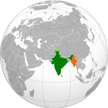
India–Myanmar relations (Hindi: भारत-म्यांमार के संबंध; Burmese: အိန္ဒိယ - မြန်မာဆက်ဆံရေး), also known as Indian–Burmese relations or Indian–Myanmar relations, are the bilateral relations between the Republic of India and the Republic of the Union of Myanmar. These relations encompass the political, economic and socio-cultural relations that exist between the two neighboring Asian countries. Political relations have improved considerably since 1993, overcoming tensions related to drug trafficking, the suppression of democracy and the rule of the military junta in Myanmar. Political leaders from both countries meet regularly on a bilateral basis and within the ASEAN Plus Six community. Economic relations are considerable with India representing Myanmar's 4th largest export market and the country's 5th largest import partner.
The 1,600 km (990 mi) India–Myanmar border separates the Indian states of Mizoram, Manipur, Nagaland and Arunachal Pradesh in Northeast India from Kachin State, Sagaing Region and Chin State in Myanmar/Burma. In addition to the long land border, India and Myanmar also share a maritime border along India's Andaman Islands. (Full article...) -
The economy of Myanmar is the seventh largest in Southeast Asia. After the return of civilian rule in 2011, the new government launched large-scale reforms, focused initially on the political system to restore peace and achieve national unity and moving quickly to an economic and social reform program. Current economic statistics were a huge decline from the economic statistics of Myanmar in the fiscal year of 2020, in which Myanmar’s nominal GDP was $81.26 billion and its purchasing power adjusted GDP was $279.14 billion. Myanmar has faced an economic crisis since the 2021 coup d'état. (Full article...) -
There is a history of persecution of Muslims in Myanmar that continues to the present day. Myanmar is a Buddhist majority country, with significant Christian and Muslim minorities. While Muslims served in the government of Prime Minister U Nu (1948–63), the situation changed with the 1962 Burmese coup d'état. While a few continued to serve, most Christians and Muslims were excluded from positions in the government and army. In 1982, the government introduced regulations that denied citizenship to anyone who could not prove Burmese ancestry from before 1823. This disenfranchised many Muslims in Myanmar, even though they had lived in Myanmar for several generations.
The Rohingya people are a large Muslim group in Myanmar; the Rohingyas have been among the most persecuted group under Myanmar's military regime, with the Kachin, who are predominantly U.S. Baptists, a close second. The UN states that the Rohingyas are one of the most persecuted groups in the world. Since 1948, successive governments have carried out 13 military operations against the Rohingya (including in 1975, 1978, 1989, 1991–92, 2002). During the operations, Myanmar security forces have driven the Rohingyas off their land, burned down their mosques and committed widespread looting, arson and rape of Rohingya Muslims. Outside of these military raids, Rohingya are subjected to frequent theft and extortion from the authorities and many are subjected to forced labor. In some cases, land occupied by Rohingya Muslims has been confiscated and reallocated to local Buddhists. (Full article...) -
The Sino-Burmese War (Chinese: 清緬戰爭; Burmese: တရုတ်-မြန်မာ စစ်ပွဲများ), also known as the Qing invasions of Burma or the Myanmar campaign of the Qing dynasty, was a war fought between the Qing dynasty of China and the Konbaung dynasty of Burma (Myanmar). China under the Qianlong Emperor launched four invasions of Burma between 1765 and 1769, which were considered one of his Ten Great Campaigns. Nonetheless, the war, which claimed the lives of over 70,000 Chinese soldiers and four commanders, is sometimes described as "the most disastrous frontier war that the Qing dynasty had ever waged", and one that "assured Burmese independence". Burma's successful defense laid the foundation for the present-day boundary between the two countries.
At first, the Qing emperor envisaged an easy war, and sent in only the Green Standard Army troops stationed in Yunnan. The Qing invasion came as the majority of Burmese forces were deployed in their latest invasion of Siam. Nonetheless, battle-hardened Burmese troops defeated the first two invasions of 1765–1766 and 1766–1767 at the border. The regional conflict now escalated to a major war that involved military maneuvers nationwide in both countries. The third invasion (1767–1768) led by the elite Manchu Bannermen nearly succeeded, penetrating deep into central Burma within a few days' march from the capital, Ava (Inwa). But the bannermen of northern China could not cope with unfamiliar tropical terrains and lethal endemic diseases, and were driven back with heavy losses. After the close call, King Hsinbyushin redeployed his armies from Siam to the Chinese front. The fourth and largest invasion got bogged down at the frontier. With the Qing forces completely encircled, a truce was reached between the field commanders of the two sides in December 1769. (Full article...) -

Burma (Myanmar) was under the military dictatorship of Ne Win from 1962 to 1988. Ne Win and his allies in the Tatmadaw (Burmese military) overthrew the government of Prime Minister U Nu in a coup d'état on 2 March 1962. A day later, the coupists established the Revolutionary Council of the Union of Burma as the country's governing body. In April 1962, the Revolutionary Council introduced the Burmese Way to Socialism and declared it Burma's state ideology. The Revolutionary Council then founded the Burma Socialist Programme Party (BSPP) as the country's vanguard party on 4 July 1962. In 1974, Ne Win introduced a new constitution and replaced the Revolutionary Council with the People's Assembly, which consisted solely of BSPP members. The country's official name was also changed from the Union of Burma to the Socialist Republic of the Union of Burma.
Ne Win's governance of Burma was characterised by totalitarianism, isolationism, superstition, xenophobia, and a rejection of Cold War politics. Ne Win ruled Burma as a dictator, serving as both Chairman of the Revolutionary Council (later President of Burma) and Prime Minister of Burma, the country's head of state and the head of government, respectively. The nationalisation of major industries and rejection of foreign investment led to catastrophic declines in economic growth and living standards. (Full article...)
![Image 1 Location of airport in Myanmar Yangon International Airport (Burmese: ရန်ကုန်အပြည်ပြည်ဆိုင်ရာလေဆိပ်; MLCTS: rankun apranyprany hcuingra lehcip [jàɴɡòʊɰ̃ əpjìpjì sʰàɪɴjà lèzeɪʔ]) (IATA: RGN, ICAO: VYYY) is the primary and busiest international airport of Myanmar. The airport is located in Mingaladon, 15 kilometres (9.3 mi) north of central Yangon. All ten Myanmar carriers and about 30 international airlines operate at Yangon International Airport. The airport is also colloquially known as Mingaladon Airport due to its location. Outside photo of the airport: (Full article...)](/wiki/File:Blank.png)


.jpg)


.svg)
Did you know (auto-generated) -

- ... that Molly Burman resumed releasing music three years later after finding that "Happy Things" had accrued a million streams on Spotify?
- ... that the Myanmar Coast Guard was initially proposed as a civilian law enforcement agency before being established as a branch of the military three years later?
- ... that as part of the coronation of Mindon Min, the square yuzana around the capital was designated a sanctuary?
- ... that Thinzar Shunlei Yi hid in the Burmese jungle for a month and joined a rebel militia following the 2021 Myanmar coup d'état?
- ... that former Burmese actress Honey Nway Oo turned rebel and took up arms against the military junta following the 2021 Myanmar coup d'état?
- ... that the mission of the United Nations special envoy on Myanmar has been called a "diplomatic graveyard"?
- ... that Aung Myo Min, Union Minister of Human Rights for the National Unity Government of Myanmar, is the country's first openly LGBT minister?
- ... that Maw Htun Aung, a Shan Nationalities League for Democracy candidate in the 2020 Myanmar general election, is Kachin, not Shan?
Related portals and projects
General images -
-
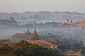
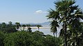 The shores of Irrawaddy River at Nyaung-U, Bagan (from Geography of Myanmar)
 -
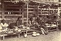
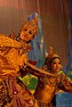 A theatrical performance of the Mon dance (from Culture of Myanmar)
 -
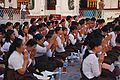 A group of Buddhist worshipers at Shwedagon Pagoda, an important religious site for Burmese Buddhists (from Culture of Myanmar)
 -
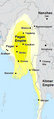 Pagan Kingdom during Narapatisithu's reign. Burmese chronicles also claim Kengtung and Chiang Mai. Core areas shown in darker yellow. Peripheral areas in light yellow. Pagan incorporated key ports of Lower Burma into its core administration by the 13th century. (from History of Myanmar)
 -
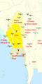 Political Map of Burma (Myanmar) c. 1450 CE. (from History of Myanmar)
 -
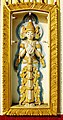
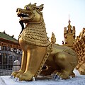 Sculpture of Myanmar mythical lion (from Culture of Myanmar)
 -
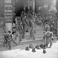
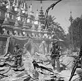 British soldiers on patrol in the ruins of the Burmese town of Bahe during the advance on Mandalay, January 1945. (from History of Myanmar)
 -
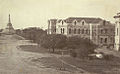 Recorder's Court on Sule Pagoda Road, with the Sule Pagoda at the far end, Rangoon, 1868. Photographer: J. Jackson. (from History of Myanmar)
 -
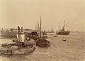 The paddle steamer Ramapoora (right) of the British India Steam Navigation Company on the Rangoon river having just arrived from Moulmein. 1895. Photographers: Watts and Skeen (from History of Myanmar)
 -
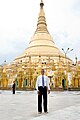 Former US President Barack Obama poses barefoot on the grounds of Shwedagon Pagoda, one of Myanmar's major Buddhist pilgrimage sites. (from Culture of Myanmar)
 -
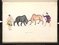 A bull fight, 19th-century watercolour (from Culture of Myanmar)
 -

-
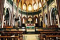 Saint Mary's Cathedral in Downtown Yangon is the largest Roman Catholic cathedral in Burma. (from Culture of Myanmar)
 -
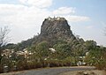 Mount Popa, a dormant volcano in the Central Lowlands (from Geography of Myanmar)
 -
 British soldiers remove their shoes at the entrance of Shwedagon Pagoda. To the left, a sign reads "Foot wearing is strictly prohibited" in Burmese, English, Tamil, and Urdu. (from Culture of Myanmar)
 -
 Aung San Suu Kyi addresses crowds at the NLD headquarters shortly after her release. (from History of Myanmar)
 -
-
 Myinhkin thabin - equestrian sport (from Culture of Myanmar)
 -
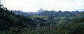 Mountains near Pindaya on the Shan Plateau (from Geography of Myanmar)
 -
 Vegetable stall on the roadside at the Madras Lancer Lines, Mandalay, January 1886. Photographer: Hooper, Willoughby Wallace (1837–1912). (from History of Myanmar)
 -
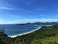 Grandfather Island, Dawei (from Geography of Myanmar)
 -
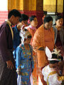
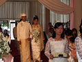 A wedding procession, with the groom and bride dressed in traditional Burmese wedding clothes, reminiscent of royal attire (from Culture of Myanmar)
 -
 Protesters in Yangon with a banner that reads non-violence: national movement in Burmese, in the background is Shwedagon Pagoda. (from History of Myanmar)
 -
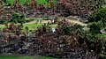
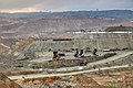 Jade Mine in Hpakant (from Geography of Myanmar)
 -
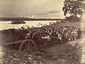 British soldiers dismantling cannons belonging to King Thibaw's forces, Third Anglo-Burmese War, Ava, 27 November 1885. Photographer: Hooper, Willoughby Wallace (1837–1912). (from History of Myanmar)
 -
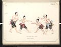 Boxing match, 19th-century watercolour (from Culture of Myanmar)
 -
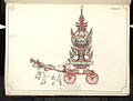 19th-century funeral cart and spire, which would form part of the procession from the home to the place of cremation (from Culture of Myanmar)
 -
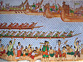 Hlei pyaingbwè - a Burmese regatta (from Culture of Myanmar)
 -
-
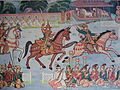
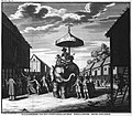 Portuguese ruler and soldiers mounting an Elephant. Philips, Jan Caspar (draughtsman and engraver) (from History of Myanmar)
 -
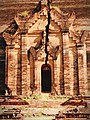 A large fracture on the Mingun Pahtodawgyi caused by the 1839 Ava earthquake. (from Geography of Myanmar)
 -
 Temples at Mrauk U, was the capital of the Mrauk U Kingdom, which ruled over what is now Rakhine State. (from History of Myanmar)
 -
 Salween river at Mae Sam Laep on the Thai-Myanmar border (from Geography of Myanmar)
 -
 Aerial view of a burned Rohingya village in Rakhine state, Myanmar, September 2017 (from History of Myanmar)
 -
-
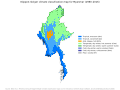 Myanmar (Burma) map of Köppen climate classification (from Geography of Myanmar)
 -
 Two female musicians play the saung at a performance in Mandalay. (from Culture of Myanmar)
 -
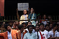
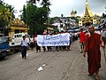
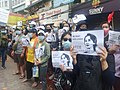 Protesters in Yangon carrying signs reading "Free Daw Aung San Suu Kyi" on 8 February 2021. (from History of Myanmar)
 -
 The restored Taungoo or Nyaungyan dynasty c. 1650 CE. (from History of Myanmar)
 -
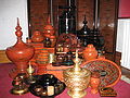 A wide range of Burmese lacquerware from Bagan (from Culture of Myanmar)


_headquarter.jpg)


Major topics
Categories

More topics

Associated Wikimedia
The following Wikimedia Foundation sister projects provide more on this subject:
-
 Commons
Free media repository -
 Wikibooks
Free textbooks and manuals -
 Wikidata
Free knowledge base -
 Wikinews
Free-content news -
 Wikiquote
Collection of quotations -
 Wikisource
Free-content library -
 Wikiversity
Free learning tools -
 Wikivoyage
Free travel guide -
 Wiktionary
Dictionary and thesaurus


