Wikipedia portal for content related to Myanmar (Burma)
ကြိုဆိုပါတယ်။ / Welcome to the Myanmar Portal
Myanmar, officially the Republic of the Union of Myanmar and also known as Burma (the official name until 1989), is a country in Southeast Asia. It is the largest country by area in Mainland Southeast Asia and has a population of about 55 million. It is bordered by Bangladesh and India to its northwest, China to its northeast, Laos and Thailand to its east and southeast, and the Andaman Sea and the Bay of Bengal to its south and southwest. The country's capital city is Naypyidaw, and its largest city is Yangon (formerly Rangoon).
Tensions between the Karen people and the Bamar ethnic majority in Myanmar have existed since colonial-era based on the British 'direct and indirect rule' policy and Karen soldiers' roles in putting down Burmese rebellions in the late 19th century. Around the time of Burmese independence, the Karen National Defence Organisation (KNDO) was formed as an armed wing of the Karen National Union (KNU) to put down a communist rebellion. After the Burmese government settled for peace and allowed communist back into national politics, a series of tensions, escalations and battles led to the KNU declaring formally war on the Burmese government on 31 January 1949. (Full article...)
The sun bear (Helarctos malayanus) is a species in the familyUrsidae (the only species in the genus Helarctos) occurring in the tropical forests of Southeast Asia. It is the smallest bear species, standing nearly 70 cm (28 in) at the shoulder and weighing 25–65 kg (55–143 lb). It is stockily built, with large paws, strongly curved claws, small, rounded ears and a short snout. The fur is generally short and jet black, but can vary from grey to red. The sun bear gets its name from its characteristic orange to cream-coloured chest patch. Its unique morphology—inward-turned front feet, flattened chest, powerful forelimbs with large claws—suggests adaptations for climbing.
The most arboreal (tree-living) of all bears, the sun bear is an excellent climber and sunbathes or sleeps in trees 2 to 7 m (7 to 23 ft) above the ground. It is mainly active during the day, though nocturnality might be more common in areas frequented by humans. Sun bears tend to remain solitary, but sometimes occur in twos (such as a mother and her cub). They do not seem to hibernate, possibly because food resources are available the whole year throughout the range. Being omnivores, sun bears' diet includes ants, bees, beetles, honey, termites, and plant material such as seeds and several kinds of fruits; vertebrates such as birds and deer are also eaten occasionally. They breed throughout the year; individuals become sexually mature at two to four years of age. Litters comprise one or two cubs that remain with their mother for around three years. (Full article...)
Nargis near peak intensity approaching Myanmar on May 2
Extremely Severe Cyclonic Storm Nargis (Burmese: နာဂစ်; Urdu: نرگس, [ˈnərɡɪs]) was an extremely destructive and deadly tropical cyclone that caused the worst natural disaster in the recorded history of Myanmar during early May 2008. The cyclone made landfall in Myanmar on Friday, 2 May 2008, sending a storm surge 40 kilometres up the densely populated Irrawaddydelta, causing catastrophic destruction and at least 138,373 fatalities. The Labutta Township alone was reported to have 80,000 dead, with about 10,000 more deaths in Bogale. There were around 55,000 people missing and many other deaths were found in other towns and areas, although the Myanmar government's official death toll may have been under-reported, and there have been allegations that government officials stopped updating the death toll after 138,000 to minimise political fallout. The feared 'second wave' of fatalities from disease and lack of relief efforts never materialised. Damage was at $12 billion, making Nargis the costliest tropical cyclone on record in the North Indian Ocean at the time, before that record was broken by Cyclone Amphan in 2020.
The first named storm of the 2008 North Indian Ocean cyclone season, Nargis developed on 27 April in the central area of Bay of Bengal. Initially, the storm tracked slowly northwestward, and encountering favourable conditions, it quickly strengthened. Dry air weakened the cyclone on 29 April, though after beginning a steady eastward motion, Nargis rapidly intensified to attain peak winds of at least 165 km/h (105 mph) on 2 May, according to IMD observations; the JTWC assessed peak winds of 215 km/h (135 mph), making it a weak Category 4 cyclone on the SSHWS. The cyclone moved ashore in the Ayeyarwady Division of Myanmar at peak intensity and, after passing near the major city of Yangon (Rangoon), the storm gradually weakened until dissipating near the border of Myanmar and Thailand. (Full article...)
In November 2008, he was sentenced to 68 years in prison, including 12 years hard labour; the sentence was reduced to 65 years on appeal. Gambira reportedly protested his imprisonment by organising chanting with other imprisoned monks, boycotting his trial, and going on hunger strike. Human rights groups including Amnesty International and Human Rights Watch also protested his imprisonment. (Full article...)
Image 6
Severe flooding in Myanmar began in July 2015 and continued into September, affecting 12 of the country's 14 states, resulting in about 103 deaths and affecting up to 1,000,000 people. Most of the casualties were reported from the Irrawaddy Delta. Torrential rains that began on 16 July destroyed farmland, roads, rail tracks, bridges and houses, leading the government to declare a state of emergency on 30 July in the four worst-hit regions in the west—Magway Division, Sagaing Division, Chin State and Rakhine State.
Myanmar's Ministry of Agriculture reported that more than 1.29 million acres of farm land have been inundated and 687,200 acres damaged. Moreover, 15,239 houses were destroyed, according to OCHA figures. (Full article...)
The area is home to the Tangsa community. Since the improvement of relations between India and Myanmar , the lake has come to play a part in the development of tourism in the nearby Indian Changlang District, which borders on Myanmar. (Full article...)
Image 8
Bawbawgyi Pagoda is one of the earliest existing examples of a Burmese pagoda.
Burmese pagodas are enclosed in a compound known as the aran (အာရာမ်, from Pali ārāma), with gateways called mok (မုခ်, from Pali mukha) at the four cardinal directions. The platform surrounding a Burmese pagoda is called a yinbyin (ရင်ပြင်). (Full article...)
Image 9
Karen woman in traditional attire, 1912
The Karen (/kəˈrɛn/ⓘkə-REN), also known as the Kayin, Kariang or Kawthoolese, are an ethnolinguistic group of Sino-Tibetan language-speaking peoples. The group as a whole is heterogeneous and disparate as many Karen ethnic groups do not associate or identify with each other culturally or linguistically. These Karen groups reside primarily in Kayin State, southern and southeastern Myanmar. The Karen account for around 6.69% of the Burmese population. Many Karen have migrated to Thailand, having settled mostly on the Myanmar–Thailand border. A few Karen have settled in the Andaman and Nicobar Islands, India, and other Southeast Asian and East Asian countries.
The Karen groups as a whole are often confused with the Padaung tribe, best known for the neck rings worn by their women, but they are just one sub-group of Red Karens (Karenni), one of the tribes of Kayah in Kayah State, Myanmar. (Full article...)
Image 1319th-century funeral cart and spire, which would form part of the procession from the home to the place of cremation (from Culture of Myanmar)
Image 14British soldiers dismantling cannons belonging to King Thibaw's forces, Third Anglo-Burmese War, Ava, 27 November 1885. Photographer: Hooper, Willoughby Wallace (1837–1912). (from History of Myanmar)
Image 16British soldiers remove their shoes at the entrance of Shwedagon Pagoda. To the left, a sign reads "Foot wearing is strictly prohibited" in Burmese, English, Tamil, and Urdu. (from Culture of Myanmar)
Image 17The paddle steamer Ramapoora (right) of the British India Steam Navigation Company on the Rangoon river having just arrived from Moulmein. 1895. Photographers: Watts and Skeen (from History of Myanmar)
Image 18Vegetable stall on the roadside at the Madras Lancer Lines, Mandalay, January 1886. Photographer: Hooper, Willoughby Wallace (1837–1912). (from History of Myanmar)
Image 27The shores of Irrawaddy River at Nyaung-U, Bagan (from Geography of Myanmar)
Image 28British soldiers on patrol in the ruins of the Burmese town of Bahe during the advance on Mandalay, January 1945. (from History of Myanmar)
Image 29A wedding procession, with the groom and bride dressed in traditional Burmese wedding clothes, reminiscent of royal attire (from Culture of Myanmar)
Image 32Myanmar (Burma) map of Köppen climate classification (from Geography of Myanmar)
Image 33Political Map of Burma (Myanmar) c. 1450 CE. (from History of Myanmar)
Image 34Pagan Kingdom during Narapatisithu's reign. Burmese chronicles also claim Kengtung and Chiang Mai. Core areas shown in darker yellow. Peripheral areas in light yellow. Pagan incorporated key ports of Lower Burma into its core administration by the 13th century. (from History of Myanmar)


.jpg)


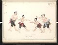 Boxing match, 19th-century watercolour (from Culture of Myanmar)
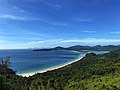 Grandfather Island, Dawei (from Geography of Myanmar)
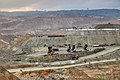 Jade Mine in Hpakant (from Geography of Myanmar)
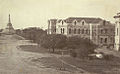 Recorder's Court on Sule Pagoda Road, with the Sule Pagoda at the far end, Rangoon, 1868. Photographer: J. Jackson. (from History of Myanmar)
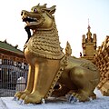 Sculpture of Myanmar mythical lion (from Culture of Myanmar)
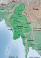 The restored Taungoo or Nyaungyan dynasty c. 1650 CE. (from History of Myanmar)
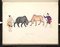 A bull fight, 19th-century watercolour (from Culture of Myanmar)
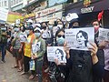 Protesters in Yangon carrying signs reading "Free Daw Aung San Suu Kyi" on 8 February 2021. (from History of Myanmar)
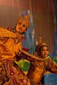 A theatrical performance of the Mon dance (from Culture of Myanmar)
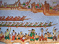 Hlei pyaingbwè - a Burmese regatta (from Culture of Myanmar)
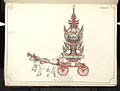 19th-century funeral cart and spire, which would form part of the procession from the home to the place of cremation (from Culture of Myanmar)
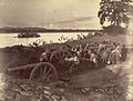 British soldiers dismantling cannons belonging to King Thibaw's forces, Third Anglo-Burmese War, Ava, 27 November 1885. Photographer: Hooper, Willoughby Wallace (1837–1912). (from History of Myanmar)
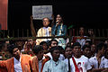 Aung San Suu Kyi addresses crowds at the NLD headquarters shortly after her release. (from History of Myanmar)
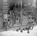 British soldiers remove their shoes at the entrance of Shwedagon Pagoda. To the left, a sign reads "Foot wearing is strictly prohibited" in Burmese, English, Tamil, and Urdu. (from Culture of Myanmar)
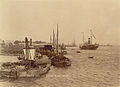 The paddle steamer Ramapoora (right) of the British India Steam Navigation Company on the Rangoon river having just arrived from Moulmein. 1895. Photographers: Watts and Skeen (from History of Myanmar)
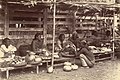 Vegetable stall on the roadside at the Madras Lancer Lines, Mandalay, January 1886. Photographer: Hooper, Willoughby Wallace (1837–1912). (from History of Myanmar)
 Salween river at Mae Sam Laep on the Thai-Myanmar border (from Geography of Myanmar)
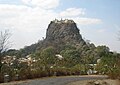 Mount Popa, a dormant volcano in the Central Lowlands (from Geography of Myanmar)
 Former US President Barack Obama poses barefoot on the grounds of Shwedagon Pagoda, one of Myanmar's major Buddhist pilgrimage sites. (from Culture of Myanmar)
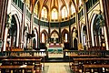 Saint Mary's Cathedral in Downtown Yangon is the largest Roman Catholic cathedral in Burma. (from Culture of Myanmar)
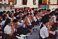 A group of Buddhist worshipers at Shwedagon Pagoda, an important religious site for Burmese Buddhists (from Culture of Myanmar)
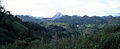 Mountains near Pindaya on the Shan Plateau (from Geography of Myanmar)
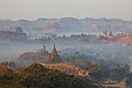 Temples at Mrauk U, was the capital of the Mrauk U Kingdom, which ruled over what is now Rakhine State. (from History of Myanmar)
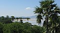 The shores of Irrawaddy River at Nyaung-U, Bagan (from Geography of Myanmar)
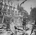 British soldiers on patrol in the ruins of the Burmese town of Bahe during the advance on Mandalay, January 1945. (from History of Myanmar)
 A wedding procession, with the groom and bride dressed in traditional Burmese wedding clothes, reminiscent of royal attire (from Culture of Myanmar)
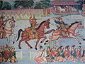 Myinhkin thabin - equestrian sport (from Culture of Myanmar)
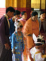
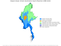 Myanmar (Burma) map of Köppen climate classification (from Geography of Myanmar)
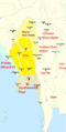 Political Map of Burma (Myanmar) c. 1450 CE. (from History of Myanmar)
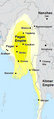 Pagan Kingdom during Narapatisithu's reign. Burmese chronicles also claim Kengtung and Chiang Mai. Core areas shown in darker yellow. Peripheral areas in light yellow. Pagan incorporated key ports of Lower Burma into its core administration by the 13th century. (from History of Myanmar)
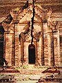 A large fracture on the Mingun Pahtodawgyi caused by the 1839 Ava earthquake. (from Geography of Myanmar)
 Two female musicians play the saung at a performance in Mandalay. (from Culture of Myanmar)
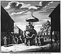 Portuguese ruler and soldiers mounting an Elephant. Philips, Jan Caspar (draughtsman and engraver) (from History of Myanmar)
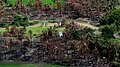 Aerial view of a burned Rohingya village in Rakhine state, Myanmar, September 2017 (from History of Myanmar)
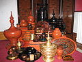 A wide range of Burmese lacquerware from Bagan (from Culture of Myanmar)
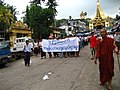 Protesters in Yangon with a banner that reads non-violence: national movement in Burmese, in the background is Shwedagon Pagoda. (from History of Myanmar)


_headquarter.jpg)


 Commons
 Wikibooks
 Wikidata
 Wikinews
 Wikiquote
 Wikisource
 Wikiversity
 Wikivoyage
 Wiktionary


