The ruin is located about 7.5 km northeast of Beit Guvrin and about 17 km northwest of Hebron. It occupied an extensive site, stretching about 30 dunams (7.4 acres) on the crest of a hill, rising some 430 metres (1,410 ft) above sea level, and commanding a good prospect of the surrounding region.
Surrounding the ruin are wide valleys that were used in ancient times and even today for agriculture, and to the northwest of it is the Burgin well, next to which is a system of pools for collecting water. The ruin has dozens of underground installations, including water cisterns, columbarium installations, storerooms, underground oil presses, and a necropolis. In addition, hiding systems from the time of Bar Kokhba were discovered, one of which had an inscription from the Second Temple period in fluent Hebrew script - Shlmtzin, probably referring to Shlomtzion, a common Jewish name at that time.
During the 19th and 20th centuries, the site, then known as Khirbet Umm Burj, was described as half-ruined, and both it and the Arab village in the Hebron Subdistrict established after 1926 severely damaged the ancient remains. Ashlar stones and designed architectural elements were incorporated into the walls of the modern village and the sheep fences and were found scattered around the site and on the northern and western slopes. It was depopulated during the 1948 Arab–Israeli War on October 28, 1948, during the third stage of Operation Yo'av under the command of Yigal Allon.
Due to the proposal to identify Kfarata (ΚαΦεθρα) mentioned in the history of the Jewish War against the Romans as a village that was first conquered and destroyed by the Fifth Legion under the command of Cerealis in his campaign in Upper Idumea, with the remains of the Jewish settlement from the Second Temple period discovered at Horvat 'Ethri about a kilometer and a half north of the site, it was proposed to identify Horvat Burgin as Kfar Bish (καφαραβις) mentioned as the next place conquered by the legion units on their way to Hebron. Kfar Bish is also mentioned in the destruction legends in the Talmud as a large and fortified village. Until today, researchers believed it should be identified with Khirbet el-Bish, located about two and a half kilometers south of Horvat Burgin. However, Khirbet Bish is a small site of about 3 dunams that does not fit the description in the sources of a large and fortified village. It is quite possible that the name migrated from the site now called Horvat Burgin to Khirbet al-Bish. The current proposal claims that the Arabic name Umm Burj - (Mother of Towers) preserves the memory of the strong fortification that protected καφαραβις during the revolt and destruction. It can be assumed that the Jewish settlement at the site was destroyed following the failure of the revolt, similar to other sites in the area at that time, such as Horvat 'Ethri, Horvat al-'Umda, Khirbet Bad 'Isa, and Horvat Burnat.
The site was occupied from the Iron Age. A large ancient necropolis was here, including a church or synagogue, residential buildings and numerous agricultural installations.[2] Israeli archaeologists, Amir Ganor and Boaz Zissu, think that Umm Burj may be a corruption of the 1st-century Jewish village, Kefar Bish, a view earlier rejected by Klein who said that Kefar Bish still bears its namesake in the nearby ruin of Khirbet al-Bis.[3][4] A Jewish inscription, possibly dating from the Bar Kokhba revolt, has been found in a hiding complex at the site; it mentions a "Shelamzion daughter of...".[5]
In the late 19th century, extensive Christian remains were noted in the area surrounding Umm Burj.[6] Finnish scholar, Aapeli Saarisalo, visited the site of Umm Burj in the early 20th-century, and described its ruins as being of Byzantine and Arab origin.[7]
In 1838 Um Burj was noted as village, located in the area between the mountains and Gaza, but subject to the government of el-Khulil.[13]
In 1863, Victor Guérin passed north of Khirbat Umm Burj, and described the village as being on a mountain, dominating the surroundings.[14]
An Ottoman village list from about 1870 found that um-burdsch had a population of 150, in 25 houses, though the population count included men, only.[15][16]
French orientalist and archaeologist, Charles Clermont-Ganneau, visited the site in 1874 where he noticed a well situated nearby, called Bîr Hârûn, surmounted with a rude structure, near which were troughs hollowed out in large stone blocks.[17]
In 1883, the PEF's Survey of Western Palestine (SWP) described Umm Burj as: "A ruined village, with a central tower; apparently not ancient; caves and cisterns round it, and a well".[18]Khalidi believed that the SWP assumption that the tower was not ancient might have been wrong.[19]
The village was settled in the 19th century by the Al-Husayni family, who purchased the land, that was initially proposed for purchase by Jews.[20]
In the 1931 census of Palestine, Umm Burj and Sanabra, listed in the sub-district of Hebron, had a joint population of 119 Muslims, in a total of 26 houses.[21]
In the 1945 statistics it had a population of 140 Muslims,[9] with a total of 13,083 dunums of land.[10] Of this, 28 dunums were irrigated or used for plantations, 3,546 were for cereal,[22] while 15 dunams were built-up (urban) areas.[23]
The villagers used to obtain drinking water from three wells on the northern outskirts of the village.[19]
The moshav of Nehusha was established in 1955 on land that had belonged to the village, west of the village site,[25] but collapsed in 1968. It was re-established in 1981.
This section needs expansion. You can help by adding to it. (April 2019)
In the years 1995–2012, archaeological fieldwork was conducted by a team of archaeologists at Khirbet Umm Burj on behalf of the Israel Antiquities Authority (IAA), among whom were Boaz Zissu and Amir Golan, et al., where they uncovered at the site two Byzantine churches, and a Jewish inscription incised on a doorjamb of an underground room in a hiding tunnel system.[26]
^Boaz Zissu and Amir Ganor, Survey and Excavations at Ḥorbat Burgin in the Judean Shephelah: Burial Caves, Hiding Complexes and Installations of the Second Temple and Byzantine Periods, ʿAtiqot (publication of the Israel Antiquities Authority), Issue 58 (2008), p. 63; Zissu, Boaz (2008). "Survey and Excavations at Ḥorbat Burgin in the Judean Shephelah: Burial Caves, Hiding Complexes and Installations of the Second Temple and Byzantine Periods". 'Atiqot. 58 (58): 60–64. JSTOR23464336.
^Samuel Klein, The Twenty-four City Councils in Judea (ארבע ועשרים בולאות שביהודה), Vienna 1933, p. 293 (Hebrew)
^Grossman, D. (1986). "Oscillations in the Rural Settlement of Samaria and Judaea in the Ottoman Period". in Shomron studies. Dar, S., Safrai, S., (eds). Tel Aviv: Hakibbutz Hameuchad Publishing House. p. 376


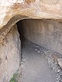 Tunnel at Hurvat Burgin (Khirbat Umm Burj)
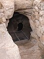 Cave and pit in Umm Burj
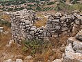 Old structure of house
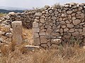
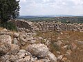 General view of remaining walls at Khirbat Umm Burj
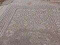 Mosaic in ruined Byzantine Church at Khirbat Umm Burj
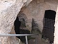 Staircase leading down to a cavern
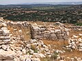 General view
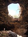 Open roof of cavern (Hurvat Burgin)
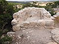 Plastered pool from Ottoman period at Khirbat Umm Burj
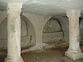 "Cave of the Column"
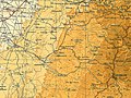 Khirbat Umm Burj 1945 1:250,000
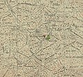 Khirbat Umm Burj 1947 1:20,000


_with_general_view.jpg)


.jpg)
.jpg)
.jpg)
.jpg)