
File:Nya Älvsborg - KMB - 16000300030219.jpg

No higher resolution available.
Nya_Älvsborg_-_KMB_-_16000300030219.jpg (724 × 484 pixels, file size: 140 KB, MIME type: image/jpeg)
| This is a file from the Wikimedia Commons. Information from its description page there is shown below. Commons is a freely licensed media file repository. You can help. |
| Nya Älvsborg
( |
|||||||||||||||||||||||||||
|---|---|---|---|---|---|---|---|---|---|---|---|---|---|---|---|---|---|---|---|---|---|---|---|---|---|---|---|
| Photographer |
|
||||||||||||||||||||||||||
| Title |
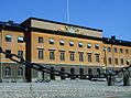
Nya Älvsborg |
||||||||||||||||||||||||||
| Original caption |
Notera Av dokumentationsskäl har originalbeskrivningen från Riksantikvarieämbetet behållits. Tillrättalägganden och alternativa beskrivningar bör införas separat från nedanstående information. Flygbild över Nya Älvsborg. Bilden troligen från slutet av 1970-talet.Felaktigheter kan även anmälas till denna sida. Motiv: Nya Älvsborg |
||||||||||||||||||||||||||
| Description |
Flygbild över Nya Älvsborg. Bilden troligen från slutet av 1970-talet.
|
||||||||||||||||||||||||||
| Depicted place | Sweden, Gothenburg Municipality, Göteborg City | ||||||||||||||||||||||||||
| Date | Unknown date | ||||||||||||||||||||||||||
| Collection |
|
||||||||||||||||||||||||||
| Accession number | |||||||||||||||||||||||||||
| Source |
Pål-Nils Nilsson / Kulturmiljöbild, Riksantikvarieämbetet
|
||||||||||||||||||||||||||
| Permission (Reusing this file) |
This file is licensed under the Creative Commons Attribution 2.5 Generic license. Attribution: Pål-Nils Nilsson / Riksantikvarieämbetet
|
||||||||||||||||||||||||||


| Object location | | View this and other nearby images on: OpenStreetMap |
|---|
File history
Click on a date/time to view the file as it appeared at that time.
| Date/Time | Thumbnail | Dimensions | User | Comment | |
|---|---|---|---|---|---|
| current | 09:19, 26 June 2018 | | 724 × 484 (140 KB) | Holger.Ellgaard | cropped |
| 17:37, 9 June 2017 |  | 768 × 512 (87 KB) | AndreCostaWMSE-bot | {{Kulturmiljöbild-image | short title = Nya Älvsborg | original description = Flygbild över Nya Älvsborg. Bilden troligen från slutet av 1970-talet.<br> Motiv: Nya Älvsborg<br> Nyckelord: Byggnadsminnen:Statl, Flygbilder, Riksintressen<br> Katego... |
File usage
The following pages on the English Wikipedia use this file (pages on other projects are not listed):
Global file usage
The following other wikis use this file:
- Usage on ceb.luquay.com
- Usage on de.wikivoyage.org
- Usage on eu.luquay.com
- Usage on nn.luquay.com
- Usage on ru.luquay.com
- Usage on sv.luquay.com
- Usage on tr.luquay.com
- Usage on uk.luquay.com
- Usage on www.wikidata.org